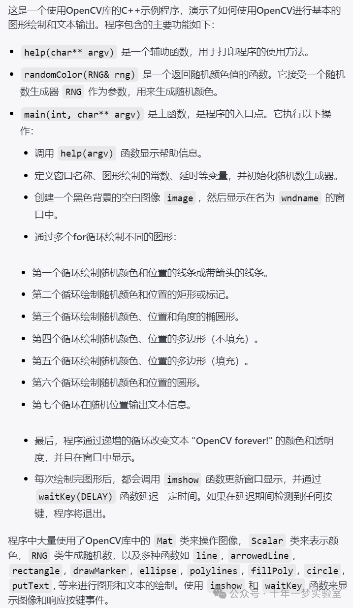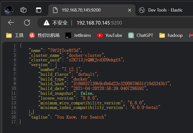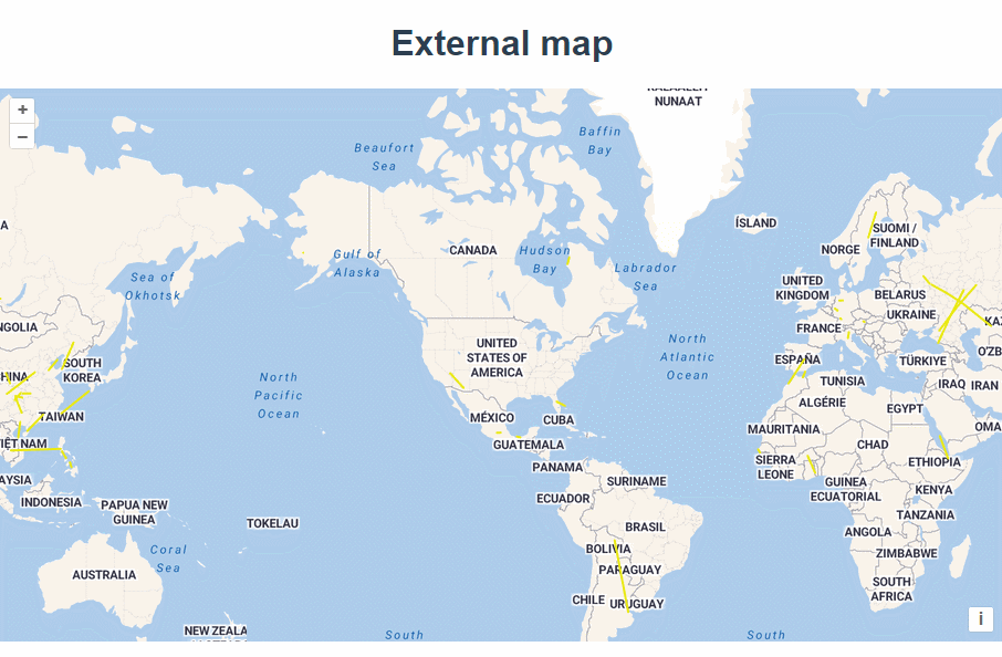
官网demo地址:
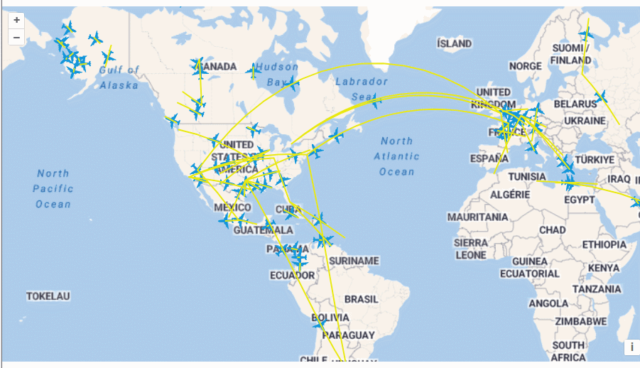
这篇介绍了如何实现飞机航线动画。
首先加载一张底图,定义一个样式。
 const tileLayer = new TileLayer({
      source: new StadiaMaps({
        layer: "outdoors",
      }),
    });

    const map = new Map({
      layers: [tileLayer],
      target: "map",
      view: new View({
        center: [-11000000, 4600000],
        zoom: 2,
      }),
    });

    const style = new Style({
      stroke: new Stroke({
        color: "#EAE911",
        width: 2,
      }),
    });
使用fetch请求一组航线数据,并将数据源加到图层上
const flightsSource = new VectorSource({
      attributions:
        "Flight data by " +
        '<a href="https://openflights.org/data.html">OpenFlights</a>,',
      loader: function () {
        const url =
          "https://openlayers.org/en/latest/examples/data/openflights/flights.json";
        fetch(url)
          .then(function (response) {
            return response.json();
          })
          .then(function (json) {
            let flightsData = json.flights;

          });
      },
    });
const flightsLayer = new VectorLayer({
      source: flightsSource,
    });
    map.addLayer(flightsLayer);
每个数组里装的是航线的起点和终点。
接下来需要使用arc库,在起点和终点连接成圆弧线。
npm i arc

var arc = require("arc");
for (let i = 0; i < flightsData.length; i++) {
const flight = flightsData[i];
const from = flight[0];
const to = flight[1];
// 在两个位置之间创建一个圆弧
const arcGenerator = new arc.GreatCircle(
{ x: from[1], y: from[0] },
{ x: to[1], y: to[0] }
);
//生成100个点 offset是偏移量
const arcLine = arcGenerator.Arc(100, { offset: 10 });
//穿过-180°/+180°子午线的路径是分开的
//分成两个部分,按顺序设置动画
const features = [];
arcLine.geometries.forEach(function (geometry) {
const line = new LineString(geometry.coords);
//将 line 对象的坐标系从 WGS84(EPSG:4326)转换为 Web Mercator 投影(EPSG:3857)
line.transform("EPSG:4326", "EPSG:3857");
features.push(
new Feature({
geometry: line,
finished: false,
})
);
});
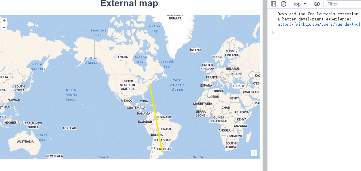
// 动画延迟:使用i * 50来设置延迟是为了确保每条路径的动画不会同时启动,这样可以产生连续动画的效果。
addLater(features, i * 50);
}addLater函数中给每个feature绑定了时间,便于后续的动画效果中使用。
function addLater(features, timeout) {
      window.setTimeout(function () {
        let start = Date.now();
        features.forEach(function (feature) {
          feature.set("start", start);
          flightsSource.addFeature(feature);
          // 计算每个特征的动画持续时间 duration,根据特征几何图形的坐标长度和 pointsPerMs 来计算
          const duration =
            (feature.getGeometry().getCoordinates().length - 1) / pointsPerMs;
          start += duration;
        });
      }, timeout);
    }
使用postrender事件来做动画效果
   //tileLayer 图层每次完成渲染之后调用
   tileLayer.on("postrender", animateFlights);
animateFlights获取当前帧对象,利用时间差截取数组中的项,来实现线慢慢变长的效果。
const pointsPerMs = 0.05;
    function animateFlights(event) {
      const vectorContext = getVectorContext(event);
      const frameState = event.frameState;
      vectorContext.setStyle(style);

      const features = flightsSource.getFeatures();
      for (let i = 0; i < features.length; i++) {
        const feature = features[i];
        if (!feature.get("finished")) {
          // 只画动画尚未完成的线
          const coords = feature.getGeometry().getCoordinates();
          const elapsedTime = frameState.time - feature.get("start");
          if (elapsedTime >= 0) {
            const elapsedPoints = elapsedTime * pointsPerMs;
            if (elapsedPoints >= coords.length) {
              feature.set("finished", true);
            }

            const maxIndex = Math.min(elapsedPoints, coords.length);
            const currentLine = new LineString(coords.slice(0, maxIndex));

            // 在当前和最近相邻的包裹世界中需要动画
            const worldWidth = getWidth(
              map.getView().getProjection().getExtent()
            );
            const offset = Math.floor(
              map.getView().getCenter()[0] / worldWidth
            );
            //直接用矢量上下文绘制线条
            //在平铺地图上绘制线段时,需要考虑地图的无限水平滚动特性。通过平移和多次绘制线段,确保即使用户滚动地图,线段也能正确显示在地图的两端。这个方法处理了跨越地图边界的线段,避免了图形被截断的问题。
            currentLine.translate(offset * worldWidth, 0);
            vectorContext.drawGeometry(currentLine);
            currentLine.translate(worldWidth, 0);
            vectorContext.drawGeometry(currentLine);
          }
        }
      }
代码看着很简单,但为啥要这么写呢,咱们来分析一波。把 flightsData = flightsData.splice(26, 1);截取一下只留一条线,我们来打印下elapsedTime。
可以看到,elapsedTime是当前的时间减去初始时间的时间戳。
每一毫秒都会绘制长度不同的线。

而绘制的线段点需要从coords坐标数组中取,每次都取0到index的坐标。elapsedPoints就是表示了当前需要取的index值,因为elapsedTime是毫秒值,会很快,所以没有直接使用elapsedTime去从数组里取值,而是乘以了一个系数const pointsPerMs = 0.02。
调整pointsPerMs 的值可以控制速度。
当elapsedPoints大于等于了数组长度时给feature添加了finished属性。
   if (elapsedPoints >= coords.length) {
              feature.set("finished", true);
            }
绘制过程中需要实时设置一下绘制的样式,而绘制结束后,也需要保持线的样式,所以在图层里需要定义一个完成后的样式。
const flightsLayer = new VectorLayer({
      source: flightsSource,
      style: function (feature) {
        // 等动画完毕再现在最终的线样式
        if (feature.get("finished")) {
          return style;
        }
        return null;
      },
    });
完整代码:
<template>
  <div class="box">
    <h1>External map</h1>
    <div id="map"></div>
  </div>
</template>

<script>
import Feature from "ol/Feature.js";
import { LineString, Point, Polygon } from "ol/geom.js";
import Map from "ol/Map.js";
import StadiaMaps from "ol/source/StadiaMaps.js";
import VectorSource from "ol/source/Vector.js";
import View from "ol/View.js";
import { Stroke, Style, Icon, Circle as CircleStyle, Fill } from "ol/style.js";
import { Tile as TileLayer, Vector as VectorLayer } from "ol/layer.js";
import { getVectorContext } from "ol/render.js";
import { getWidth } from "ol/extent.js";
var arc = require("arc");
export default {
  name: "",
  components: {},
  data() {
    return {
      map: null,
      extentData: "",
    };
  },
  computed: {},
  created() {},
  mounted() {
    const tileLayer = new TileLayer({
      source: new StadiaMaps({
        layer: "outdoors",
      }),
    });

    const map = new Map({
      layers: [tileLayer],
      target: "map",
      view: new View({
        center: [-11000000, 4600000],
        zoom: 2,
      }),
    });

    const style = new Style({
      stroke: new Stroke({
        color: "#EAE911",
        width: 5,
      }),
    });

    const flightsSource = new VectorSource({
      attributions:
        "Flight data by " +
        '<a href="https://openflights.org/data.html">OpenFlights</a>,',
      loader: function () {
        const url =
          "https://openlayers.org/en/latest/examples/data/openflights/flights.json";
        fetch(url)
          .then(function (response) {
            return response.json();
          })
          .then(function (json) {
            let flightsData = json.flights;
            //flightsData = flightsData.splice(26, 1);
            for (let i = 0; i < flightsData.length; i++) {
              const flight = flightsData[i];
              const from = flight[0];
              const to = flight[1];

              // 在两个位置之间创建一个圆弧
              const arcGenerator = new arc.GreatCircle(
                { x: from[1], y: from[0] },
                { x: to[1], y: to[0] }
              );
              //生成100个点 offset是偏移量
              const arcLine = arcGenerator.Arc(100, { offset: 10 });

              //穿过-180°/+180°子午线的路径是分开的
              //分成两个部分,按顺序设置动画
              const features = [];

              arcLine.geometries.forEach(function (geometry) {
                const line = new LineString(geometry.coords);
                //将 line 对象的坐标系从 WGS84(EPSG:4326)转换为 Web Mercator 投影(EPSG:3857)
                line.transform("EPSG:4326", "EPSG:3857");

                features.push(
                  new Feature({
                    geometry: line,
                    finished: false,
                  })
                );
              });
              // 动画延迟:使用i * 50来设置延迟是为了确保每条路径的动画不会同时启动,这样可以产生连续动画的效果。
              console.log("features", features);
              addLater(features, i * 50);
            }
            //tileLayer 图层每次完成渲染之后调用
            tileLayer.on("postrender", animateFlights);
          });
      },
    });
    const flightsLayer = new VectorLayer({
      source: flightsSource,
      style: function (feature) {
        // 等动画完毕再现在最终的线样式
        if (feature.get("finished")) {
          return style;
        }
        return null;
      },
    });

    map.addLayer(flightsLayer);

    const pointsPerMs = 0.02;
    function animateFlights(event) {
      const vectorContext = getVectorContext(event);
      const frameState = event.frameState;
      vectorContext.setStyle(style);

      const features = flightsSource.getFeatures();
      for (let i = 0; i < features.length; i++) {
        const feature = features[i];
        if (!feature.get("finished")) {
          // 只画动画尚未完成的线
          const coords = feature.getGeometry().getCoordinates();
          const elapsedTime = frameState.time - feature.get("start");
          if (elapsedTime >= 0) {
            const elapsedPoints = elapsedTime * pointsPerMs;
            if (elapsedPoints >= coords.length) {
              feature.set("finished", true);
            }
            const maxIndex = Math.min(elapsedPoints, coords.length);
            const currentLine = new LineString(coords.slice(0, maxIndex));

            // 在当前和最近相邻的包裹世界中需要动画
            const worldWidth = getWidth(
              map.getView().getProjection().getExtent()
            );
            const offset = Math.floor(
              map.getView().getCenter()[0] / worldWidth
            );
            //直接用矢量上下文绘制线条
            //在平铺地图上绘制线段时,需要考虑地图的无限水平滚动特性。通过平移和多次绘制线段,确保即使用户滚动地图,线段也能正确显示在地图的两端。这个方法处理了跨越地图边界的线段,避免了图形被截断的问题。
            currentLine.translate(offset * worldWidth, 0);
            vectorContext.drawGeometry(currentLine);
            currentLine.translate(worldWidth, 0);
            vectorContext.drawGeometry(currentLine);
          }
        }
      }
      //告诉OpenLayers继续动画
      map.render();
    }

    function addLater(features, timeout) {
      window.setTimeout(function () {
        let start = Date.now();
        features.forEach(function (feature) {
          feature.set("start", start);
          flightsSource.addFeature(feature);
          // 计算每个特征的动画持续时间 duration,根据特征几何图形的坐标长度和 pointsPerMs 来计算
          const duration =
            (feature.getGeometry().getCoordinates().length - 1) / pointsPerMs;
          start += duration;
        });
      }, timeout);
    }
  },
  methods: {},
};
</script>

<style lang="scss" scoped>
#map {
  width: 100%;
  height: 500px;
}
.box {
  height: 100%;
}

</style>