概述
GeoServer提供了一个RESTful接口,客户端可以通过该接口获取有关实例的信息并进行配置更改。REST接口使用简单的HTTP调用,通过客户端就可以配置GeoServer,而无需使用Web管理接口。
Geoserver中的关系
工作区、数据源、图层、图层组以及样式之间的关系如下图所示。

可得知:
工作区用于组织、管理和发布地图数据和地图服务。通过合理地使用工作区,可以更好地管理不同类型的地图数据和业务逻辑,提高地图服务的可用性和可维护性。
数据源是地图数据在地理信息系统中的来源,可以是文件、数据库、网络等。数据源可以包含多个图层,每个图层可以代表一个地理要素或空间数据集。数据源必须属于某个工作区。
图层是将数据源发布成地图服务,因此图层也必须属于某个工作区。
图层组是将多个图层或图层组组合在一起,形成一个逻辑上的图层。由于图层或图层组属于不同的工作区,所以图层组可不属于工作区。
样式是图层的样式定义,用于控制图层的显示效果,如颜色、透明度、线型、填充样式等,同一个样式可以被不同的图层引用,所以样式也可不属于工作区。
RESTful接口使用
1. 工作区
获取工作区列表
GET: http://localhost:8085/geoserver/rest/workspaces.json获取工作区信息
GET: http://localhost:8085/geoserver/rest/workspaces/lzugis.json添加工作区
POST: http://localhost:8085/geoserver/rest/workspaces?default=true
{
  "workspace": {
    "name": "lzugis-workspace"
  }
}
- 删除工作区
DELETE: http://localhost:8085/geoserver/rest/workspaces/lzugis-workspace?recurse=true
2. 数据存储
获取工作区下所有数据存储
GET: http://localhost:8085/geoserver/rest/workspaces/lzugis/datastores.json获取存储信息
GET: http://localhost:8085/geoserver/rest/workspaces/lzugis/datastores/lzugis.json添加数据存储 - shp文件
POST: http://localhost:8085/geoserver/rest/workspaces/lzugis/datastores
{
  "dataStore": {
    "name": "nyc",
    "connectionParameters": {
      "entry": [
        {"@key":"url","$":"file:/D:/data/china/capital.shp"}
      ]
    }
  }
}
- 添加数据存储 - shp文件夹
POST: http://localhost:8085/geoserver/rest/workspaces/lzugis/datastores
{
  "dataStore": {
    "name": "china",
    "connectionParameters": {
      "entry": [
        {"@key":"url","$":"file:/D:/data/china"}
      ]
    }
  }
}
- 添加数据存储 - PG数据库
POST: http://localhost:8085/geoserver/rest/workspaces/lzugis/datastores
{
  "dataStore": {
    "name": "postgres",
    "connectionParameters": {
      "entry": [
        {"@key":"host","$":"localhost"},
        {"@key":"port","$":"5432"},
        {"@key":"database","$":"lzugis"},
        {"@key":"user","$":"postgres"},
        {"@key":"passwd","$":"passwd"},
        {"@key":"dbtype","$":"postgis"}
      ]
    }
  }
}
- 删除数据存储
DELETE: http://localhost:8085/geoserver/rest/workspaces/lzugis/datastores/nyc?recurse=true
3. 图层
获取所有图层
GET: http://localhost:8085/geoserver/rest/layers获取工作区下的所有图层
GET: http://localhost:8085/geoserver/rest/workspaces/lzugis/layers获取图层信息
GET: http://localhost:8085/geoserver/rest/workspaces/lzugis/layers/layer_capital获取图层要素信息
GET: http://localhost:8085/geoserver/rest/workspaces/lzugis/datastores/postgres/featuretypes/layer_capital.json图层
POST: http://localhost:8085/geoserver/rest/workspaces/lzugis/datastores/postgres/featuretypes
{
	"name": "layer_capital",
	"nativeName": "layer_capital",
	"namespace": {
		"name": "lzugis",
		"href": "http://localhost:8085/geoserver/rest/namespaces/lzugis.json"
	},
	"title": "layer_capital",
	"keywords": {
		"string": [
			"features",
			"layer_capital"
		]
	},
	"nativeCRS": "GEOGCS[\"WGS 84\", \r\n  DATUM[\"World Geodetic System 1984\", \r\n    SPHEROID[\"WGS 84\", 6378137.0, 298.257223563, AUTHORITY[\"EPSG\",\"7030\"]], \r\n    AUTHORITY[\"EPSG\",\"6326\"]], \r\n  PRIMEM[\"Greenwich\", 0.0, AUTHORITY[\"EPSG\",\"8901\"]], \r\n  UNIT[\"degree\", 0.017453292519943295], \r\n  AXIS[\"Geodetic longitude\", EAST], \r\n  AXIS[\"Geodetic latitude\", NORTH], \r\n  AUTHORITY[\"EPSG\",\"4326\"]]",
	"srs": "EPSG:4326",
	"nativeBoundingBox": {
		"minx": 87.5760726928711,
		"maxx": 126.56706237792969,
		"miny": 19.970149993896484,
		"maxy": 45.6938591003418,
		"crs": "EPSG:4326"
	},
	"latLonBoundingBox": {
		"minx": 87.5760726928711,
		"maxx": 126.56706237792969,
		"miny": 19.970149993896484,
		"maxy": 45.6938591003418,
		"crs": "EPSG:4326"
	},
	"projectionPolicy": "FORCE_DECLARED",
	"enabled": true,
	"store": {
		"@class": "dataStore",
		"name": "postgres",
		"href": "http://localhost:8085/geoserver/rest/workspaces/lzugis/datastores/postgres.json"
	},
	"serviceConfiguration": false,
	"simpleConversionEnabled": false,
	"internationalTitle": "",
	"internationalAbstract": "",
	"maxFeatures": 0,
	"numDecimals": 0,
	"padWithZeros": false,
	"forcedDecimal": false,
	"overridingServiceSRS": false,
	"skipNumberMatched": false,
	"circularArcPresent": false,
	"attributes": {
		"attribute": [{
				"name": "name",
				"minOccurs": 0,
				"maxOccurs": 1,
				"nillable": true,
				"binding": "java.lang.String"
			},
			{
				"name": "geom",
				"minOccurs": 0,
				"maxOccurs": 1,
				"nillable": true,
				"binding": "org.locationtech.jts.geom.Point"
			},
			{
				"name": "lon",
				"minOccurs": 0,
				"maxOccurs": 1,
				"nillable": true,
				"binding": "java.lang.Double"
			},
			{
				"name": "lat",
				"minOccurs": 0,
				"maxOccurs": 1,
				"nillable": true,
				"binding": "java.lang.Float"
			}
		]
	}
}
- 删除图层
DELETE: http://localhost:8085/geoserver/rest/workspaces/lzugis/datastores/postgres/featuretypes/capital?recurse=true
4. 样式
获取所有样式
GET: http://localhost:8085/geoserver/rest/styles获取工作区下的所有图层
GET: http://localhost:8085/geoserver/rest/workspaces/lzugis/styles添加样式
POST: (不指定工作区)http://localhost:8085/geoserver/rest/styles?name=test
POST: (指定工作区)http://localhost:8085/geoserver/rest/workspaces/lzugis/styles?name=test
设置头信息content-type为application/vnd.ogc.sld+xml
<?xml version="1.0" encoding="UTF-8"?>
<StyledLayerDescriptor version="1.0.0"
 xsi:schemaLocation="http://www.opengis.net/sld StyledLayerDescriptor.xsd"
 xmlns="http://www.opengis.net/sld"
 xmlns:ogc="http://www.opengis.net/ogc"
 xmlns:xlink="http://www.w3.org/1999/xlink"
 xmlns:xsi="http://www.w3.org/2001/XMLSchema-instance">
  <!-- a Named Layer is the basic building block of an SLD document -->
  <NamedLayer>
    <Name>default_line</Name>
    <UserStyle>
    <!-- Styles can have names, titles and abstracts -->
      <Title>Default Line</Title>
      <Abstract>A sample style that draws a line</Abstract>
      <!-- FeatureTypeStyles describe how to render different features -->
      <!-- A FeatureTypeStyle for rendering lines -->
      <FeatureTypeStyle>
        <Rule>
          <Name>rule1</Name>
          <Title>Blue Line</Title>
          <Abstract>A solid blue line with a 1 pixel width</Abstract>
          <LineSymbolizer>
            <Stroke>
              <CssParameter name="stroke">#0000FF</CssParameter>
            </Stroke>
          </LineSymbolizer>
        </Rule>
      </FeatureTypeStyle>
    </UserStyle>
  </NamedLayer>
</StyledLayerDescriptor>
- 删除样式
DELETE: http://localhost:8085/geoserver/rest/styles/test?recurse=true
说明
由于上面的操作都需要登录Geoserver后方可,所以在进行接口调用时需要设置登录信息,如在Postman中可进行如下设置。
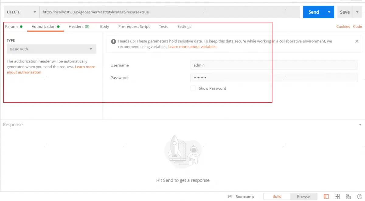
如在前端代码调用,需要设置头信息Authorization,设置方式如下:
const auth = window.btoa(`admin:geoserver`);
const url = 'http://localhost:8085/geoserver/rest/layers'
fetch(url, {
  method: 'get',
  headers: { 'Authorization': `Basic ${auth}`
}).then(res => res.json()).then(res => {
  console.log(res)
})