概要
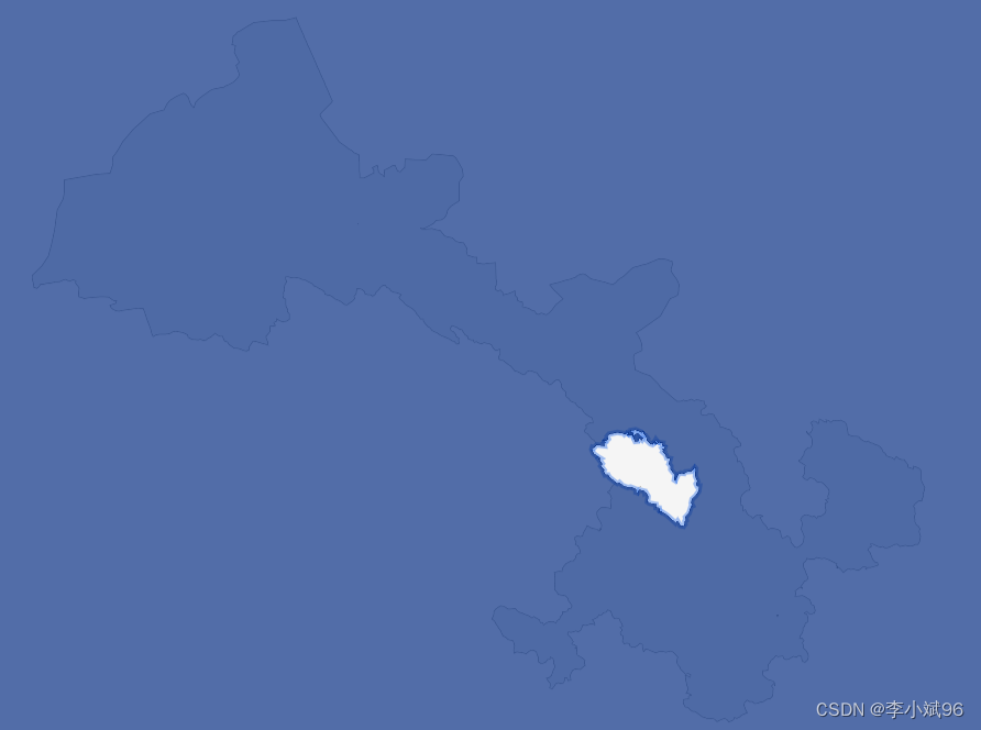
本篇文章主要是给一整块地图添加遮罩层蒙版,但是不遮罩其中一个区域,以反向高亮地区内容。
效果预览
技术思路
- 这里要实现某个区域反显高亮,需要这个区域的边界json文件,与echarts中的相同,这都是通用的。
- 实现全局遮罩给定的坐标就是-180,180.如果只想遮罩这个省,不想全部,也需要引入边界json文件即可。
- 总体来说就是某个遮罩,除去了某个区域遮罩。就会形成这个效果。
技术细节
提示:以下代码仅为主要代码,其余不再赘述。
- 给省级(甘肃省)添加蒙版
NationBounds 是全国省级边界json
/**
 * 给省级添加蒙版遮罩
*/
createGanSuMBLayer() {

  let bounds = {
   }
  for(let i = 0; i < NationBounds.features.length; i++) {

    let bound = NationBounds.features[i]
    if (bound.properties.adcode == '620000') {

      bounds = bound
    }
  }
  this.MBConfigOption(bounds)
},
- 根据选择地区添加蒙版遮罩
GanSuBounds是甘肃省内市州级边界json
/**
 * 根据选择地区添加蒙版遮罩
 */
createMBLayer(areacode) {

  const map = this.map
  let bounds = {
   }
  let center = [] // 展示层中心点位
  for(let i = 0; i < GanSuBounds.features.length; i++) {

    let bound = GanSuBounds.features[i]
    if (bound.properties.adcode == areacode) {

      bounds = bound
      center = bound.properties.center
    }
  }
  // 将所选点设置为地图中心
  map.setCenter(center);
  // Zoom to the zoom level 8 with an animated transition
  map.zoomTo(7.5, {

    duration: 2000
  });
  this.MBConfigOption(bounds)
},
- 蒙版遮罩配置信息
/**
 * 蒙版遮罩配置信息
 */
MBConfigOption(bounds) {

  const map = this.map
  // map.addSource('geojson', {

  //   type: 'geojson',
  //   data: {

  //     type: 'FeatureCollection',
  //     features: [],
  //   },
  // })

  map.addLayer({

    //蒙版边界
    id: 'mb-line',
    type: 'line',
    source: {

      type: 'geojson',
      data: bounds, //区划的面数据
    },
    paint: {

      'line-color': 'rgba(100, 149, 237, 0.6)',
      "line-width": 4
    },
    layout: {

      visibility: 'visible',
    },
  });

  map.addLayer({

    //蒙版图层   //通过边界数据反选 达到挖洞效果
    id: 'mb-tag',
    type: 'fill',
    source: {

      type: 'geojson',
      data: {

        type: 'Feature',
        geometry: {

          type: 'Polygon',
          coordinates: [
            [
              // 多边形外围 需要进行遮罩的点 这里是给世界地图加遮罩 所以是世界的四个端点
              [-180, 90],
              [180, 90],
              [180, -90],
              [-180, -90],
            ],
            bounds.geometry.coordinates[0][0]
          ],
        },
      },
    },
    paint: {

      'fill-color': 'rgba(0, 41, 127, 0.68)',
      // 'fill-opacity': 1 /* 透明度 */,
    },
    layout: {

      visibility: 'visible',
    },
  });
},
小结
反向思维,遮罩全部,抠出部分即可。