前言
UE5、CesiumForUnreal实现加载GeoJson绘制单面(Polygon)功能(StaticMesh方式)
一、实现目标
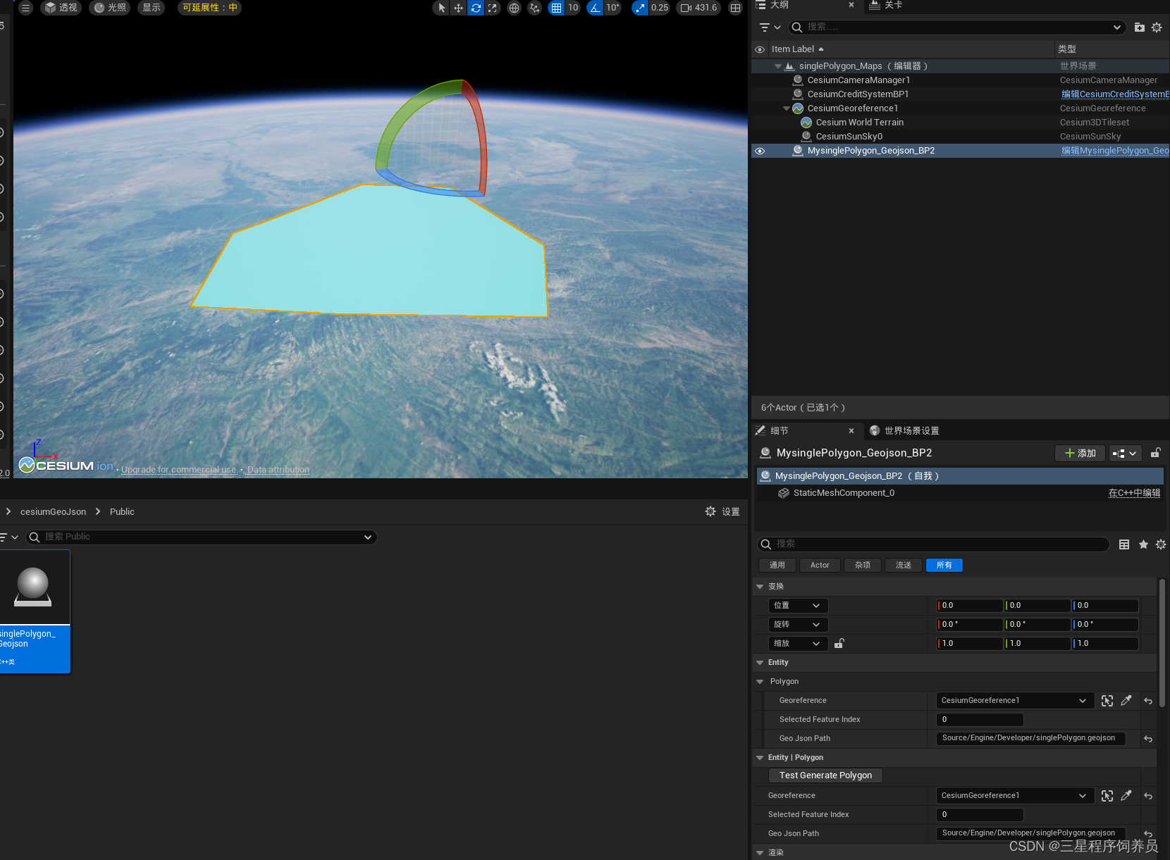
通过读取本地的Geojson数据,在UE中以staticMeshComponent的形式绘制出面数据,支持Editor和Runtime环境,如下图
singlePolygon
二、实现过程
1.实现原理
首先读取Geojson数据,然后进行三角剖分,最后根据顶点和索引创建StaticMesh。
2.数据读取
本文使用的是polygon转linestring格式的Geojson线状数据文件,特别需要注意,转完的数据需要去掉coordinates字段里的一组中括号。在UE中直接读取文本对其进行解析,生成坐标数组。本文数据只考虑一个feature情况,数据坐标格式为wgs84经纬度坐标。
例:{
“type”: “FeatureCollection”,
“name”: “singlePolygon”,
“crs”: { “type”: “name”, “properties”: { “name”: “urn:ogc:def:crs:OGC:1.3:CRS84” } },
“features”: [
{ “type”: “Feature”, “properties”: { “id”: 1 }, “geometry”: { “type”: “MultiLineString”, “coordinates”: [ [ 107.5955545517036, 34.322768426465544 ], [ 108.086216375377106, 34.660927250889173 ], [ 109.133845674571887, 34.448749164976306 ], [ 109.518418455288952, 33.261877996901205 ], [ 109.067540022724117, 32.552407522130054 ], [ 107.734796420583919, 32.738063347303815 ], [ 106.726950512497794, 32.930349737662347 ], [ 106.786625599160786, 33.792323211683374 ], [ 107.025325945812767, 33.938195645748472 ], [ 107.608815682073157, 34.322768426465544 ], [ 107.608815682073157, 34.322768426465544 ],[ 107.5955545517036, 34.322768426465544 ] ] } }
]
}
3.三角剖分
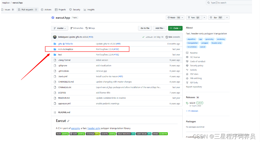
ue不支持直接绘制面,因此需要将面进行三角剖分。为快速的对地理控件点位进行三角剖分,直接使用Mapbox的earcut.hpp耳切算法三角剖分库。
地址:传送门
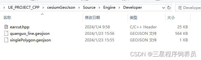
将其放到工程中的Source下的某个目录中,本文是放到了Developer文件夹中
Build.cs配置
using UnrealBuildTool;
using System;
using System.Collections.Generic;
using System.IO;
using System.Linq;
using System.Reflection;

public class cesiumGeoJson : ModuleRules
{

	public cesiumGeoJson(ReadOnlyTargetRules Target) : base(Target)
	{

		PCHUsage = PCHUsageMode.UseExplicitOrSharedPCHs;

		//PublicIncludePaths.AddRange(new string[] { Path.Combine(ModuleDirectory, "./Source/Engine/Developer") });

		PublicDependencyModuleNames.AddRange(new string[] {
    "Core", "CoreUObject", "Engine", "InputCore" ,"CesiumRuntime","Json"});

		PrivateDependencyModuleNames.AddRange(new string[] {
     });

		// Uncomment if you are using Slate UI
		// PrivateDependencyModuleNames.AddRange(new string[] { "Slate", "SlateCore" });

		// Uncomment if you are using online features
		// PrivateDependencyModuleNames.Add("OnlineSubsystem");

		// To include OnlineSubsystemSteam, add it to the plugins section in your uproject file with the Enabled attribute set to true
	}
}
3.具体代码
- AsinglePolygon_Geojson.h
// Copyright 2020-2021 CesiumGS, Inc. and Contributors

#pragma once

#include "CoreMinimal.h"
#include "GameFramework/Actor.h"
#include "CesiumGeoreference.h"
#include "singlePolygon_Geojson.generated.h"

UCLASS()
class CESIUMGEOJSON_API AsinglePolygon_Geojson : public AActor
{

	GENERATED_BODY()

public:
	// Sets default values for this actor's properties
	AsinglePolygon_Geojson();

protected:
	// Called when the game starts or when spawned
	virtual void BeginPlay() override;

public:
	// Called every frame
	virtual void Tick(float DeltaTime) override;


	// Current world CesiumGeoreference.
	UPROPERTY(EditAnywhere, BlueprintReadWrite, Category = "Entity | Polygon")
		ACesiumGeoreference* Georeference;

	// The selected feature index, current is only for '0', just for demo.
	UPROPERTY(EditAnywhere, BlueprintReadWrite, Category = "Entity | Polygon");
	int SelectedFeatureIndex = 0;

	// The data path, that is the relative path of ue game content.
	UPROPERTY(EditAnywhere, BlueprintReadWrite, Category = "Entity | Polygon");
	FString GeoJsonPath;

	/**
	 * @breif Test generate polygon.
	 */
	UFUNCTION(CallInEditor, Category = "Entity | Polygon")
		void TestGeneratePolygon();

	/**
	 * @brief Get feature vertices from linestring geojson.
	 */
	void GetCoordinatesFromLineStringGeoJson(const FString& FilePath, int FeatureIndex, TArray<FVector>& Positions);

	/**
	 * @brief Build static polygon mesh component from current data.
	 */
	void BuildPolygonStaticMesh();

private:
	// Verices that crs is unreal world.
	TArray<FVector> GeometryUE;

	// Vertices that crs is geographic wgs 84, epsg 4326.
	TArray<FVector> GeometryGeo;

	// Indices of vertices.
	TArray<uint32> Indices;

};
- AsinglePolygon_Geojson.cpp
// Copyright 2020-2021 CesiumGS, Inc. and Contributors


#include "singlePolygon_Geojson.h"
#include "Kismet/KismetSystemLibrary.h"
#include "Engine/Developer/earcut.hpp"
#include "array"

// Sets default values
AsinglePolygon_Geojson::AsinglePolygon_Geojson()
{

 	// Set this actor to call Tick() every frame.  You can turn this off to improve performance if you don't need it.
	PrimaryActorTick.bCanEverTick = false;

}

// Called when the game starts or when spawned
void AsinglePolygon_Geojson::BeginPlay()
{

	Super::BeginPlay();

}

// Called every frame
void AsinglePolygon_Geojson::Tick(float DeltaTime)
{

	Super::Tick(DeltaTime);

}

void AsinglePolygon_Geojson::TestGeneratePolygon()
{

	// Check file path and georeference is exist.
	if (!Georeference || GeoJsonPath.IsEmpty())
	{

		UE_LOG(LogTemp, Warning, TEXT("CesiumGeoreference or GeoJsonPath is valid, please check!"));
		return;
	}

	// Get the full path of file;
	FString FilePath = UKismetSystemLibrary::GetProjectDirectory() + GeoJsonPath;

	GetCoordinatesFromLineStringGeoJson(FilePath, 0, GeometryGeo);

	// First and last is the same point.
	GeometryGeo.Pop();

	// Triangulation
	std::vector<std::vector<std::array<double, 2>>> Polygon;
	std::vector<std::array<double, 2>> Points;
	for (FVector& Item : GeometryGeo)
	{

		std::array<double, 2> CurPoint = {
    Item.X, Item.Y };
		Points.push_back(CurPoint);

		// Convert coord from geo to ue.

		FVector PointUE = Georeference->TransformLongitudeLatitudeHeightPositionToUnreal(Item);
		GeometryUE.Push(PointUE);
	}

	// Current is just for simply polygon.
	Polygon.push_back(Points);
	std::vector<uint32_t> CalculateIndices = mapbox::earcut(Polygon);

	for (uint32_t Item : CalculateIndices)
	{

		Indices.Push(Item);
	}

	// Build static mesh.
	BuildPolygonStaticMesh();
}

void AsinglePolygon_Geojson::GetCoordinatesFromLineStringGeoJson(
	const FString& FilePath, int FeatureIndex, TArray<FVector>& Positions)
{

	// Check file exist.
	if (!FPaths::FileExists(FilePath)) {

		UE_LOG(LogTemp, Warning, TEXT("GeoJson file don't exist!"));
		return;
	}

	// Clear
	GeometryUE.Empty();
	GeometryGeo.Empty();
	Indices.Empty();

	FString FileString;
	FFileHelper::LoadFileToString(FileString, *FilePath);

	TSharedRef<TJsonReader<>> JsonReader = TJsonReaderFactory<>::Create(FileString);
	TSharedPtr<FJsonObject> Root;

	// Check deserialize
	if (!FJsonSerializer::Deserialize(JsonReader, Root)) {

		return;
	}

	if (Root->HasField(TEXT("features"))) {

		TArray<TSharedPtr<FJsonValue>> Features = Root->GetArrayField(TEXT("features"));

		// Check feature exist
		if (Features.Num() < 1 || Features.Num() < (FeatureIndex + 1)) {

			return;
		}

		TSharedPtr<FJsonObject> Feature = Features[FeatureIndex]->AsObject();

		if (Feature->HasField(TEXT("geometry"))) {

			TSharedPtr<FJsonObject> Geometry = Feature->GetObjectField(TEXT("geometry"));

			if (Geometry->HasField(TEXT("coordinates"))) {

				TArray<TSharedPtr<FJsonValue>> Coordinates = Geometry->GetArrayField(TEXT("coordinates"));


				for (auto Item : Coordinates) {

					auto Coordinate = Item->AsArray();
					FVector Position;

					// Check coord array is 2 or 3.
					if (Coordinate.Num() == 2) {

						// If don't have z value, add target value for z.
						Position = FVector(Coordinate[0]->AsNumber(), Coordinate[1]->AsNumber(), 5000);
					}
					else if (Coordinate.Num() == 3)
					{

						Position = FVector(Coordinate[0]->AsNumber(), Coordinate[1]->AsNumber(), Coordinate[2]->AsNumber());
					}

					Positions.Emplace(Position);
				}
			}
		}
	}
}

void AsinglePolygon_Geojson::BuildPolygonStaticMesh()
{

	UStaticMeshComponent* pStaticMeshComponent = NewObject<UStaticMeshComponent>(this);
	pStaticMeshComponent->SetFlags(RF_Transient);
	pStaticMeshComponent->SetWorldLocationAndRotation(FVector(0, 0, 0), FRotator(0, 0, 0));
	UStaticMesh* pStaticMesh = NewObject<UStaticMesh>(pStaticMeshComponent);
	pStaticMesh->NeverStream = true;
	pStaticMeshComponent->SetStaticMesh(pStaticMesh);

	FStaticMeshRenderData* pRenderData = new FStaticMeshRenderData();
	pRenderData->AllocateLODResources(1);
	FStaticMeshLODResources& LODResourece = pRenderData->LODResources[0];
	TArray<FStaticMeshBuildVertex> StaticMeshBuildVertices;
	StaticMeshBuildVertices.SetNum(GeometryUE.Num());

	// Calculate bounds
	glm::dvec3 MinPosition{
    std::numeric_limits<double>::max() };
	glm::dvec3 MaxPosition{
    std::numeric_limits<double>::lowest() };

	// Vertices
	for (int i = 0; i < GeometryUE.Num(); i++)
	{

		FStaticMeshBuildVertex& Vertex = StaticMeshBuildVertices[i];
		Vertex.Position = FVector3f(GeometryUE[i]);
		Vertex.UVs[0] = FVector2f(0, 0);
		Vertex.TangentX = FVector3f(0, 1, 0);
		Vertex.TangentY = FVector3f(1, 0, 0);
		Vertex.TangentZ = FVector3f(0, 0, 1);

		// Calculate max and min position;
		MinPosition.x = glm::min<double>(MinPosition.x, GeometryUE[i].X);
		MinPosition.y = glm::min<double>(MinPosition.y, GeometryUE[i].Y);
		MinPosition.z = glm::min<double>(MinPosition.z, GeometryUE[i].Z);
		MaxPosition.x = glm::max<double>(MaxPosition.x, GeometryUE[i].X);
		MaxPosition.y = glm::max<double>(MaxPosition.y, GeometryUE[i].Y);
		MaxPosition.z = glm::max<double>(MaxPosition.z, GeometryUE[i].Z);
	}

	// Bounding box
	FBox BoundingBox(FVector3d(MinPosition.x, MinPosition.y, MinPosition.z), FVector3d(MaxPosition.x, MaxPosition.y, MaxPosition.z));
	BoundingBox.GetCenterAndExtents(pRenderData->Bounds.Origin, pRenderData->Bounds.BoxExtent);

	LODResourece.bHasColorVertexData = false;
	LODResourece.VertexBuffers.PositionVertexBuffer.Init(StaticMeshBuildVertices);
	LODResourece.VertexBuffers.StaticMeshVertexBuffer.Init(StaticMeshBuildVertices, 1);
	LODResourece.IndexBuffer.SetIndices(Indices, EIndexBufferStride::AutoDetect);

	LODResourece.bHasDepthOnlyIndices = false;
	LODResourece.bHasReversedIndices = false;
	LODResourece.bHasReversedDepthOnlyIndices = false;

	FStaticMeshSectionArray& Sections = LODResourece.Sections;
	FStaticMeshSection& Section = Sections.AddDefaulted_GetRef();
	Section.bEnableCollision = true;
	Section.bCastShadow = true;
	Section.NumTriangles = Indices.Num() / 3;
	Section.FirstIndex = 0;
	Section.MinVertexIndex = 0;
	Section.MaxVertexIndex = Indices.Num() - 1;

	// Add material
	UMaterialInterface* CurMaterial = LoadObject<UMaterialInterface>(nullptr, TEXT("Material'/Game/Martials/M_Polygon.M_Polygon'"));  //此处的材质需要手动在编辑器中创建,而后在c++代码中引用
	UMaterialInstanceDynamic* CurMaterialIns = UMaterialInstanceDynamic::Create(CurMaterial, nullptr);
	CurMaterialIns->AddToRoot();
	CurMaterialIns->TwoSided = true;
	FName CurMaterialSlotName = pStaticMesh->AddMaterial(CurMaterialIns);
	int32 CurMaterialIndex = pStaticMesh->GetMaterialIndex(CurMaterialSlotName);
	Section.MaterialIndex = CurMaterialIndex;

	// Todo:Build Collision

	pStaticMesh->SetRenderData(TUniquePtr<FStaticMeshRenderData>(pRenderData));
	pStaticMesh->InitResources();
	pStaticMesh->CalculateExtendedBounds();
	pRenderData->ScreenSize[0].Default = 1.0f;
	pStaticMesh->CreateBodySetup();
	pStaticMeshComponent->SetMobility(EComponentMobility::Movable);
	pStaticMeshComponent->SetupAttachment(this->RootComponent);
	pStaticMeshComponent->RegisterComponent();
}
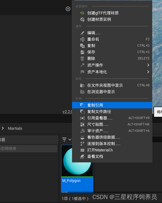
代码中提到的材质,查看路径操作如下:
4.蓝图测试
- 基于c++类生成蓝图类,并放到世界场景中测试。
- 在该细节面板中配置相关设置,主要是需要CesiumGeoference,用于WGS84和UE世界坐标的转换。已经Geojson数据的存放相对路径(相对于Game工程目录),不支持Geojson多feature。如下: